
 by
by The profession of geological engineer is one of the job which evolves very rapidly over time. Unlike other fields, it requires regular updating of skills and learning new tools.
Today, one of the tools that have become indispensable to geologists is computers science.
In this article, we are going to discover the necessity of computers science in the profession of a geological engineer.
Not just that !
We will also show you the computer skills you need to acquire to better practice this profession.
And finally, we will guide you and give you the ways and means that you can use to better acquire these skills, quickly and at a lower cost.
Why computers science ?
Computer science and geology have become two complementary disciplines. From its name “Computing”, there are two terms: Information and Automatic. Computer science therefore refers to the fact of processing information automatically.
There is therefore a close relationship between computers science and our job as a geological engineer. Because we geologists research and process information, but not just any type of information, we process geospatial information . The mineral resources that we explore, the geological structures that we survey, the natural phenomena that we study (…) are geospatial information .
As information, these data must be processed. In time, the manual processing of geospatial data could suffice. This is why a geologist could:
- Hand draw geological sections and level plans on the graph papers
- Manually create geological map
- Manually represent the structural measurements through the Wulff diagram , on the tracing paper
- Draw by hand the thin sections that were observed under the microscope
- Mount with various level plans superimposed on a transparent support a 3D model of the deposit studied.
well today
All of this is obsolete.
Today, the geologist is called upon to process his geospatial information not manually, but automatically. This obliges him to use a specialized tool in the automatic processing of information that is the computer science.
This has even given rise to various synonymous disciplines, namely:
- Geomatics,
- GIS,
- Computer science applied to geology,
- Geo-informatics, etc.
Advantages offered by computers to the geological engineer
Automatically processing geospatial information offers various advantages to the geological engineer. Not only the classic advantages that we all know from computers science , namely:
- Automate laborious and repetitive tasks,
- Save time and efficiency,
- Professionalize the presentation of its results.
The advantages that computing offers to geology are much more phenomenal.
To better detail them, we will go through the data by evoking their various fields of use.
This is why in the following lines, we are going to tell you about the computer skills you need to acquire to better exercise the profession of geological engineer.
Geo-informatics skills to acquire
We can never say it enough, today the work of a geologist is no longer limited to field work. To be carried out a complete work, you will need to use the computer tool, in this case software designed to allow you to carry out these different tasks.
Below are the 5 axes in which computers science is essential for the geological engineer:
Collection, processing and representation of data
Geospatial data collection
Computing through multiple applications allows direct recording of field data through spreadsheets that can be directly loaded into dedicated software for proper processing.
Similarly, thanks to various online platforms, multiple ready-to-use data can be easily downloaded and used for a specific study. These include satellite imagery, digital terrain model (DTM) (…) which contain an infinity of data that only needs to be extracted.
Data processing
One of the greatest revolution offered by computing is the execution of complex operations that could have taken years for man. This is particularly true in the interpolation of values in cartography or in the estimation of mining resources.
Indeed, the interpretations made by the geologist are deduced from only a few samples. To get a general idea about the studied variable, it is necessary to make the interpolation in order to determine the value studied in places where the sampling was not carried out.
Doing the interpolation manually is a headache, especially if the sampling mesh is spaced out, if the area to be covered is large or if there are several variables for which this interpolation should be done.
Yet with a geosoftware , doing the interpolation is a very simple task. You just need to learn how to do it.
Furthermore, the application of resource estimation methods uses complex mathematical formulas, even for a doctor of mathematics; these kinds of operations would have been annoying.
Just the inverse distance method can get you dead-end kilometer formulas, and the kriging method is the most sadistic. It uses differential equations, integrals and multiple mathematical functions. I’m willing to bet you’d like to stay away from that math.
Well, you’re in luck.
Neither was IT; we would have to.
Fortunately, computers are there to get rid of them. When you run an estimate on a mining software, the software bustles about performing all its powerful operations and gives you the results in a fraction of a second. Is not cool!
Elaboration of maps, geological sections and level plans

In the absence of the computer tool, drawing a map as complex as you can imagine. Tens of scientists gathered around a gigantic table. Each responsible for drawing part of the map based on the elements reported by the explorers.
The drawing of a map therefore took years and years because it depended on the elements brought back after the prospecting. Therefore, draftsmen should be distinguished by high precision, maximum care. Because every day new elements were added to the map and the map should not be soiled otherwise it would be inaccessible.
The old maps were drawn on fragile supports. They were difficult to manipulate, share and update. Computers have allowed us to create cards with a:
- Better support: digital cartography has offered man the possibility of recording his map on a digital medium (memory card, flash disk, etc.) which is easier to transport and reduces the risk of alteration due to humidity
- Variety of media: not only can the map be saved in digital format on a memory card or flash disk, but it can also be printed on various paper formats (A4, A3, A2, A1).
- Easy to handle: no more question of making dozens of turns on a table to better observe the card that is there. Observing a digital map offers a valuable advantage, that of zooming out or zooming in on the map in order to see the details of a specific part. You have this latitude to move around the map, go forwards, backwards, up and down without worrying that the map will tear or get dirty.
- Easy to share: the current map is easily shareable. In no time, it can be easily uploaded and anyone can view, edit and improve it.
- Easy to edit or update: the map you recreate can be modified as many times as you want. When you have things to add or change.
Representation of geological structures and studies of the stability of a rock block
Representing geological planes is one of the most important things in mineral exploration.
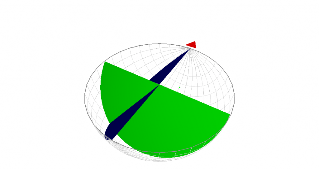
Because this representation allows us to:
- Detect the different families of geological planes
- Perform statistical analyzes to determine the frequency of these plans
- Identify the major orientation of these plans
- Make a stability study of a fractured block
- Easily and accurately measure the angle between 2 or more planes
- Do a stability analysis of a rock.
Such a study is only possible with the computer tool. Otherwise we would be forced into the laborious operations of manually representing structural measurements through the Wulff diagram , on the tracing paper
Creation of 3D geological models and modeling of geological layers.
In traditional geological works, geological investigations and results are illustrated by 2D maps such as well sections, geological profiles and plans.
The inability to represent in 3 dimensions geological phenomena such as strata, structures and reliefs constituted a loss and a distortion of spatial information.
By using the information tool, it becomes possible to do 3D modeling and visualization. The body and the geological environment can be understood and expressed directly in 3D. The computer tool makes it possible to:
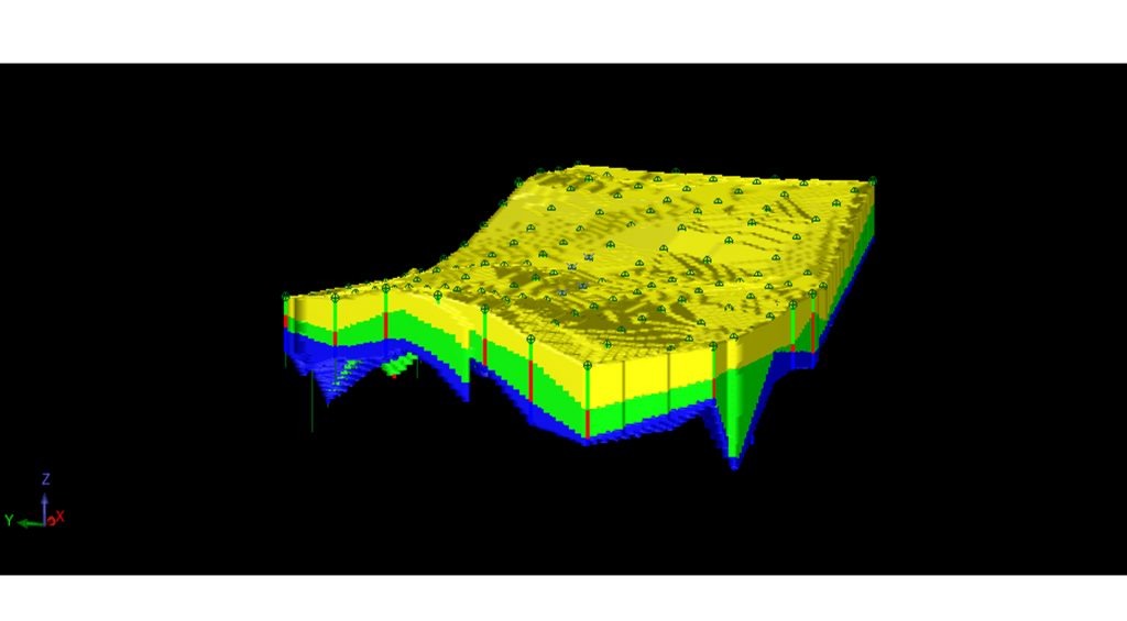
- Visualize geological phenomena in 3 dimensions
- Model even the thinnest layers
- Mining resource estimation and geostatistical analysis
- Evaluate the average grade of a deposit and know its volume and tonnage
- Statistically analyze a deposit to optimize the estimated resources in order to guarantee the profitability of a mining operation
Mine planning and mining coordination
Modeling a deposit and estimating its mineral resources is not enough to generate profit in a mining operation . The most important thing is to know how to recover as much as possible of the greatest quantity of the ore as well as the good quality of ore. Such recovery is only possible by doing mine planning.
With the computer tool, this task is feasible. Mining can thus be coordinated in time and space.
How to acquire computer skills useful for mining engineering quickly and cheaply?
Now that you know how fundamental the computer tool is in your job as a mine engineer, would you like to be trained on this tool. Then the trainings below will help you.